 |
| Ancient Art |

The Democratic Socialist Republic of Sri Lanka was called Ceylon until 1972. In ancient sources it is referred to as Lanka, Taprobane and also as Serendib. As a tourism destination it indeed has everything to ensure ‘serendipity’: for making happy and unexpected discoveries. Despite its size of only 65,525 square kilometers the island offers a wide variety of landscapes and great natural beauty: from picturesque beaches to impressive mountains, from rainforests to red desert-like plains, from spectacular botanical gardens to unique wildlife. The profusion of heritage and cultural attractions, including seven UNESCO World Heritage sites, means the tagline “Small Island, Big Trip” used in promotional campaigns hardly promises too much.
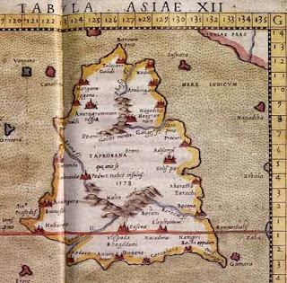
Historical Map of Sri Lanka (Tolami's Map)
Sri Lanka is a pear-shaped island in the Indian Ocean, situated between latitudes 5°54'N and 9°52'N, and longitudes 79°39'E and 81°53'E, and separated from India by a channel only 35 km wide at its narrowest. The island measures 435 km from north to south, and 225 km from east to west at its widest.
That the island is a detached part of the continental Deccan plateau is evident from its continental shelf and rock formations. Nine-tenths of the island is composed of crystalline rocks of pre-Cambrian age. The greater part of the lowland is composed of very strongly metamorphic Palaeozoic rocks of the Vijayan series. There are areas of Miocene limestone in the northwest and southeast, and very small patches of fossiliferous Jurassic formations in the northwest (Puttalam) and Sabaragamuwa Province (Ratnapura). Plio-Pleistocene gravels occur as isolated patches in the northwest and southeast, and there are quaternary deposits in river valleys and along much of the east and west coasts.Sri Lanka became an island probably in the late Miocene times, the southwestern sector having been the first to separate from India, with alternate shallow floodings and elevations at varioustimes thereafter.
There are also indications that parts of the island have, through subsidence,elevation, erosion and even faulting, produced three peneplains or erosions levels, at sea level to120m, 300m to 700m, and 910m to 2,438m, respectively. Two-thirds of the island is lowland,with the highlands, at a general elevation of l, 400-l,800m, covering some 10,400 sq.km in the
There are also indications that parts of the island have, through subsidence,elevation, erosion and even faulting, produced three peneplains or erosions levels, at sea level to120m, 300m to 700m, and 910m to 2,438m, respectively. Two-thirds of the island is lowland,with the highlands, at a general elevation of l, 400-l,800m, covering some 10,400 sq.km in the
south-central part of the country.
Climate
Sri Lanka has a good climate for holidaymakers throughout the year. The south west monsoon brings rain to the western, southern and central regions from May to July. The north eastern monsoon occurs in the north and east in December and January.
 |
| North Eastern Monsoon |
The driest and best seasons are from December to March for the west coast, the south coast and the Hill Country; from April to September for the ancient cities region and the east coast. The Low Lands have a tropical climate with an average temperature of 27C. The Central Hills are cooler, with temperatures dropping to 14C.
 |
| Nuwara Eliya |
 |
| Nuwara Eliya Banglo |
Sri Lanka’s climate means that one can always find the ‘right’ beach season somewhere on the coast. However, December through March are the months when most foreign tourists visit, escaping the European winter. The Christmas-New Year period is an especially popular period.
Tourist Attractions in Sri Lanka
- Brilliant Beaches&Marine Systems
- National Parks and Wildlife Reserves
- Eco-tourism
- Festivals
- World Heritage Sites
- Sri Lankan Food


